|
Rain gauge data for
1/11/2014:
|
|
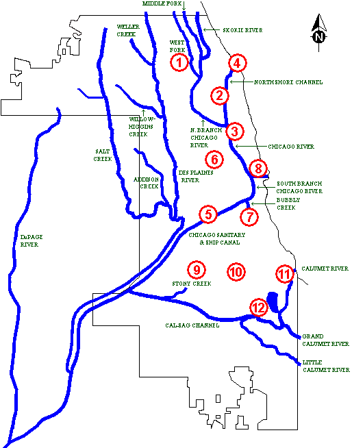
Gauge Number
|
Precipitation
(inches) |
Gauge Name
|
Address |
|
|
1
|
.06
|
Glenview |
1333 Shermer Road, Glenview |
 |
|
2
|
.08
|
North Side WRP |
3500 Howard Street, Skokie |
|
3
|
.09
|
North Branch Pump Station |
4840 N. Francisco Avenue, Chicago |
|
4
|
.06
|
Wilmette |
613 Sheridan Road, Wilmette |
|
Avg
|
.07
|
North Basin Average |
|
5
|
.00
|
West Side |
6001 W. Pershing Road, Cicero |
|
6
|
.06
|
Springfield |
1747 N. Springfield Avenue, Chicago |
|
7
|
.07
|
Racine Avenue Pump Station |
3838 S. Racine, Chicago |
|
8
|
.10
|
MOB |
100 E. Erie Stree, Chicago |
|
Avg
|
.05
|
Central Basin Average |
|
9
|
.15
|
Melvina Ditch |
8644 S. Natchez Ave., Burbank |
|
10
|
out
|
87th & Western |
87th St. & Western Ave., Chicago |
|
11
|
.09
|
95th Stree P.S., Chicago |
9525 S. Baltimore, Chicago |
|
12
|
.12
|
Calumet WRP |
400 E. 130th Street, Chicago |
|
Avg
|
.13
|
South Basin Average |